| diagram | 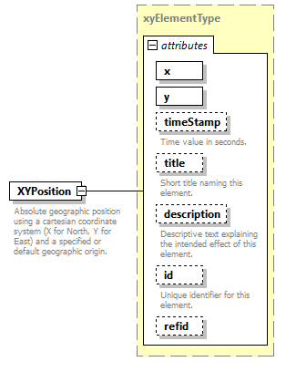 |
||||||||||||||||||||||||||||||||||||||||||||||||||||||||
| type | xyElementType | ||||||||||||||||||||||||||||||||||||||||||||||||||||||||
| properties |
|
||||||||||||||||||||||||||||||||||||||||||||||||||||||||
| used by |
|
||||||||||||||||||||||||||||||||||||||||||||||||||||||||
| attributes |
|
||||||||||||||||||||||||||||||||||||||||||||||||||||||||
| annotation |
|
||||||||||||||||||||||||||||||||||||||||||||||||||||||||
| source | <xsd:element name="XYPosition" type="xyElementType"> <xsd:annotation> <xsd:documentation>Absolute geographic position using a cartesian coordinate system (X for North, Y for East) and a specified or default geographic origin.</xsd:documentation> </xsd:annotation> </xsd:element> |
XML Schema documentation generated by XMLSpy Schema Editor http://www.altova.com/xmlspy