| diagram | 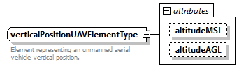 |
||||||||||||||||||
| used by |
|
||||||||||||||||||
| attributes |
|
||||||||||||||||||
| annotation |
|
||||||||||||||||||
| source | <xsd:complexType name="verticalPositionUAVElementType"> <xsd:annotation> <xsd:documentation>Element representing an unmanned aerial vehicle vertical position.</xsd:documentation> </xsd:annotation> <xsd:attribute name="altitudeMSL" type="nonNegativeScalarType" use="optional"/> <xsd:attribute name="altitudeAGL" type="nonNegativeScalarType" use="optional"/> <!-- Mean Sea Level (MSL) altitute is an absolute altitute required by Federal Aviation Regulations (FARs), and assigned by Air Traffic Control (ATC) for enroute flight --> <!-- Above Ground Level (AGL) is an altitude in feet at or above the local terrain --> </xsd:complexType> |
attribute verticalPositionUAVElementType/@altitudeMSL
| type | nonNegativeScalarType | ||||||
| properties |
|
||||||
| facets |
|
||||||
| source | <xsd:attribute name="altitudeMSL" type="nonNegativeScalarType" use="optional"/> |
attribute verticalPositionUAVElementType/@altitudeAGL
| type | nonNegativeScalarType | ||||||
| properties |
|
||||||
| facets |
|
||||||
| source | <xsd:attribute name="altitudeAGL" type="nonNegativeScalarType" use="optional"/> |
XML Schema documentation generated by XMLSpy Schema Editor http://www.altova.com/xmlspy